#EAPS#EAPS106
Clouds and Thunderstorms §
- The making of clouds begins when heat causes surface water to evaporate and become water vapor, which is an invisible gas. This creates warm, moist air, which then rises
- When warm moist air rises it expands due to lower pressures with altitude, causing it to cool. Think same energy spread out over a larger volume
- Cold air cannot hold as much water vapor as warm air, thus cooling causes some of the water vapor to condense back into droplets and ice crystals, forming clouds
- If an external door is blown open inside a spaceship then the moist air inside will become cloudy as the water vapor condenses, the temperature will drop, and the pressure will drop.
- Clouds are classified based on their height - higher clouds carry stronger winds and more rain and are called thunderstorms
- The biggest thunderstorms are associated with cumulonimbus clouds
- Lowest to highest clouds
- Stratocumulus
- Cumulus (fair weather)
- Cumulonimbus - the big stormy, dangerous ones
- Weather fronts mark the boundary of air masses that have different temperatures
- Cold fronts give rise to strong thunderstorms because they rapidly push warm moist air high into the Atmosphere, forming Cumulonimbus clouds
- A cold front first piles up the warm air, causing wind, temperatures to rise and rain to fall. Then comes clear air and cold.
- Cold air is dry as it cannot hold much moisture (water vapor)
- Dry air is heavier than moist air
- Warm fronts give rise to gentle showers as warm air gradually gains altitude, forming Cumulus clouds
Lightning, Hail, and Downbursts §
- Strong thunderstorms produce many types of hazards
- Lightning
- Strong winds
- Hail
- Tornadoes
- Lightning
- Lightning is a sudden electrostatic discharge between oppositely charged regions of a cloud or between a cloud and the ground
- A strong separation of electric charges occurs as falling ice particles strip rising water molecules of their electrons.
- Cloud to cloud lightning is from the top of the cloud (which is positively charged) to the bottom of the cloud (which is negatively charged). It then goes from there to the ground (which is positively charged)
- Because lightning heats an object it hits incredibly fast, it can cause that object to expand so rapidly it explodes
- Lightning bolts almost instantaneously raise the temperature of air to over 50,000 degrees Fahrenheit causing a rapid expansion of the air that results in a shock wave we hear as thunder
- Light travels faster than sound so we see lightning before we hear thunder
- Thunder travels at about 5 seconds per mile (3 seconds per kilometer)
- Lightning will occur in any medium in which particles rub together, especially volcanic ash
- You don’t need to be hit directly by lightning to be killed
- Electricity can pass through the ground (especially wet ground) and into living things stopping their hearts
- Lightning Safety
- Do not take refuge under tall isolated objects that can act as step leaders
- Thunder cannot occur without lightning, even if you do not see it
- The lightning crouch is supposed to prevent electricity from passing through your heart
- Not recommended anymore because people were trying to abuse it. It technically works, but it’s not complete safety
- Hail
- Hail is a sign of a strong thunderstorm
- Hail is made from ice crystals that travel repeatedly above and below the freezing line, enabling additional water to freeze onto them until they become too heavy for the updrafts and fall to the ground
- Microbursts or Downbursts
- Areas of rapidly descending cold air that causes strong wind shear that can knock down trees and houses like a tornado
- Microbursts are particularly hazardous to aircraft during landings
- Fortunately air traffic controllers can detect downbursts using Doppler radar and steer airplanes clear
Tornado Development §
- A tornado is a violently rotating column of air in contact with both the surface and a cumulonimbus cloud.
- Tornadoes are often spawned by supercells, giant cumulonimbus clouds that rotate
- Supercells don’t always form tornadoes
- A supercell forms when strong wind shear leads to a horizontal vortex that is then uplifted and rotates into a vertical vortex
- A supercell can focus the rotating motion into a tighter vortex called a mesocyclone, which can further focus into a tornado
- Tornadoes form by focusing the rotation of supercells into a series of faster rotating structures: mesocyclone to wall cloud to tornado
- The rapid spinning of a mesocyclone enables more efficient updraft of warm, moist air, providing more energy for the supercell resulting in stronger winds
- Hail often arrives before a tornado because the supercell leads with the downdraft regions
- Near the ground winds will blow toward a tornado, feeding the strong updraft. Wind blows outward from a tornado several hundred feet above the ground
- Cyclones, typhoons, and Hurricanes always spin counter clockwise in northern hemisphere and clockwise in southern hemisphere due to the Earth’s spin
Tornado Strength §
- Many parts of the world experience tornadoes, but none with the same frequency as the U.S.
- 100 tornadoes hit the U.S. each year
- 300 in Europe
- 15 in Australia
- Most US supercells form in the Midwest and move East, spawning about 1000 tornadoes per year
- The Midwest has the right ingredients for supercell formation
- Cold dry air from the North collides with warm moist air from the Gulf to form cumulonimbus clouds
- Winds from the jet streams cause the cumulonimbus clouds to experience horizontally shear
- Warm dry air from the Southwest lifts and rotates the horizontal vortex, generating a supercell
- Peak tornado season in the U.S. occurs in the Spring, when waters from the Gulf of Mexico begin to warm while cold air masses still descend from the North
- Enhanced Fujita (EF) Scale rates tornado strength based on the damage it inflicts, which is then used to estimate wind speed

- It’s not based on wind speed, since its hard to measure wind speed of tornadoes. Its instead based on damage
- Below EF0 is considered a Dust Devil, a wannabe tornado
- Wind speed can mainly be measured via radar, but most radars are in fixed locations
- Tornado wind speeds are difficult to measure because tornadoes are almost never within line of sight of radar stations due to the curvature of the Earth
- Most doppler radar stations can only measure wind speed a few kilometers above the ground
- Measuring wind speed within a tornado is one of the main goals of professional storm chasers, as it will help to develop numerical models used to gain insight into predicting tornado formation and behavior
- TOTO (TOtable Tornado Observatory)
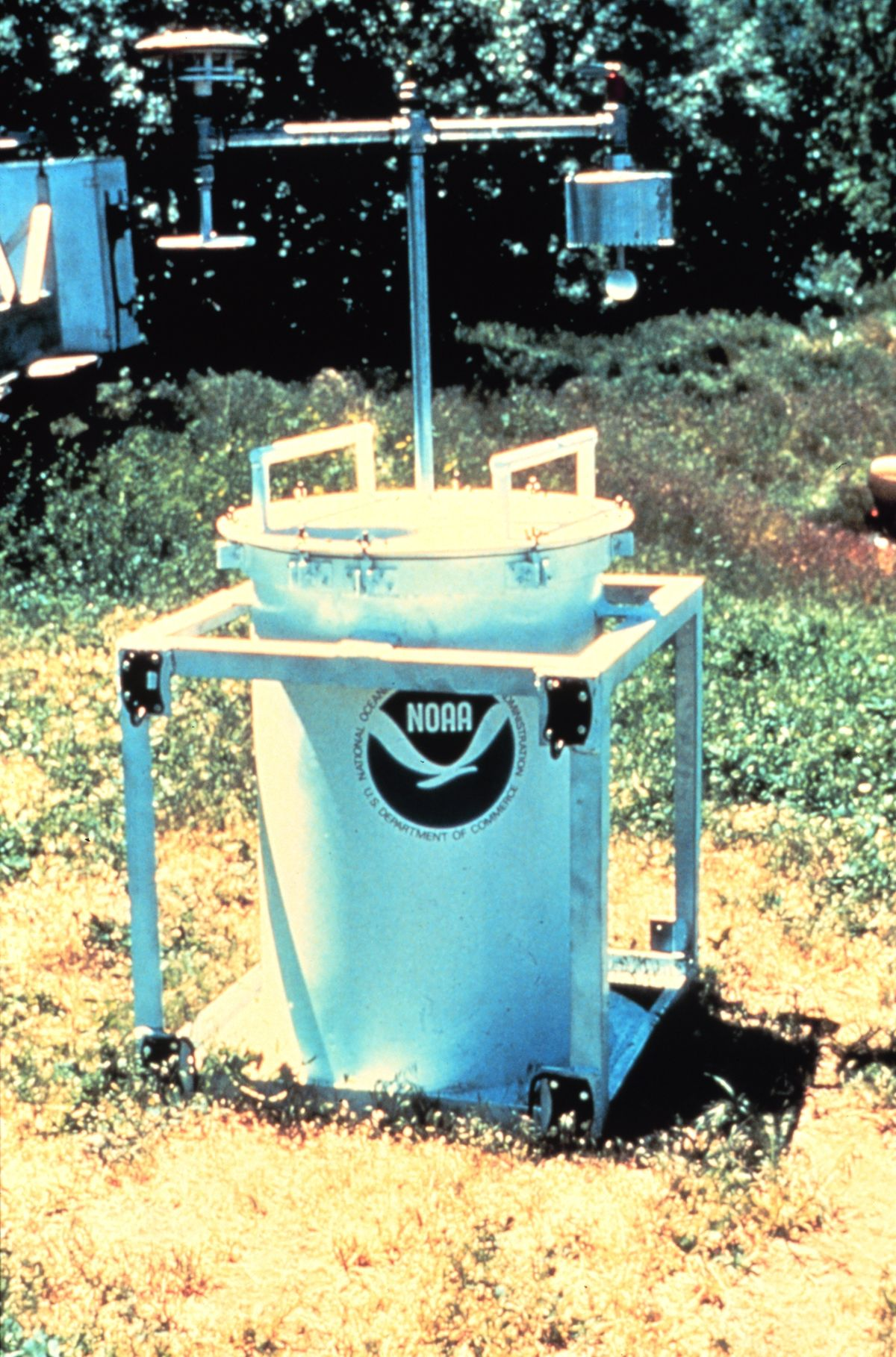
- Designed to be placed in the path of a tornado to record wind speeds, pressure, humidity, and temperature
- Instruments are in the can - no flying balls like in Twister
- Deployed several times in the 1980s without success
- Today scientists try and deploy digital instruments that hug the ground like TWISTEX (Tactical Weather-Instrumented Sampling in/near Tornadoes EXperiment)
- Most tornadoes are weak (EF0 and EF1s)
- Even though EF4s and EF5s are only a small fraction of all tornadoes (1%) they cause the most deaths (67% of all fatalities)
- Bigger EF rating is usually associated with larger tornadoes
- Tornado damage is really sharp in its range, if you’re outside of the range, you might not have any damage done. A tornado can hit one side of the road but not the other
- The widest tornado ever recorded was 2.6 miles wide in El Reno, Oklahoma in 2013
- A single Doppler radar measured winds of 300 miles per hour
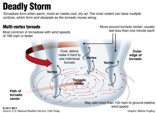
- Not possible to have two tornadoes next to each other like in Twister
- However, you can get multiple vortex tornadoes
- Each vortex can rotate around a large tornadic center
Tornado Dangers and Safety §
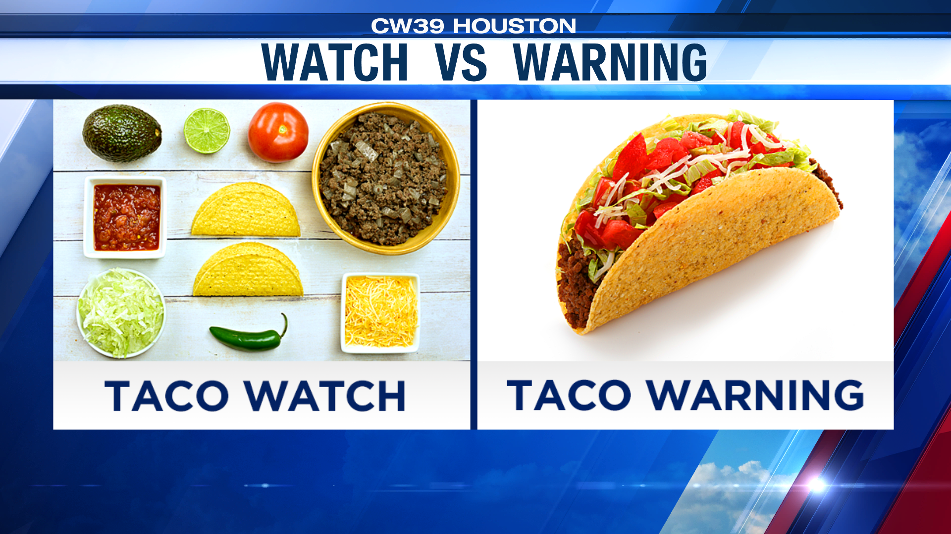
- Tornado/severe thunderstorm watch: Weather conditions are favorable for tornadoes. Be on alert.
- Tornado/severe thunderstorm warning: A tornado has been spotted or is indicated by radar. Take immediate action to be safe.
- Tornado Safety
- Be prepared
- Have a way to receive tornado warnings
- Do not rely on sirens, they aren’t really meant to be heard indoors
- Tornadoes aren’t always visible either, they can be wrapped in rain
- If outdoors, get inside
- If inside, go to the basement. If no basement go to a small ground floor interior room without windows
- If in a car and you see a tornado:
- If there’s no traffic drive away at right angles to the direction the tornado is traveling
- If stuck in traffic and no obvious shelter, get to a low spot (ditch or culvert) and lie down to avoid flying debris
- DO NOT HIDE UNDER AN OVERPASS
- If at home, stay home, do not get in your car and drive
- Bank vaults are the strongest structures to be in during a tornado (but also probably not likely to be in that spot)
- Tornado shelters are very safe
- Flying objects are the biggest danger from being too close to a tornado
- There is no “eye” of a tornado, the entire supercell is above. There’s no center of the storm that is clear
Tornadoes §
- Rotating column of air
- In contact with the surface
- Hanging downward from a cumuliform cloud
- Often observable as a funnel cloud or circulating debris/dust at the ground
- Most intense of all atmospheric circulations